Sandlapper Journal · Charleston Real Estate

Homes on The Battery

Three related waterfront settings – each with a different architectural era, public realm, outlook, and ownership experience.

Charleston’s Battery is often treated as one continuous waterfront address. From a distance, it is. From a homeowner’s perspective, it is better understood as three distinct residential settings: the High Battery along East Battery Street, the homes facing White Point Garden, and the Low Battery along Murray Boulevard.

Each shares the same waterfront promenade and South of Broad setting, but the relationship among the homes, harbor, park, street, and seawall changes considerably from one section to the next.

Same promenade, different perspectives.
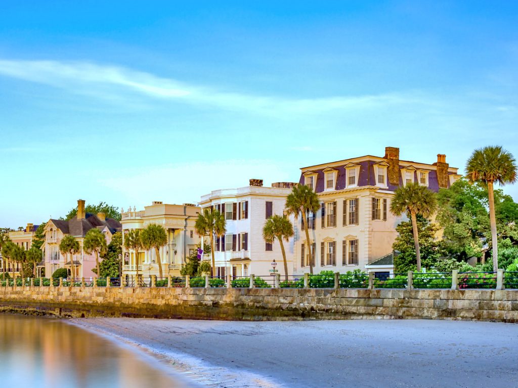
Large homes positioned close together along the seawall of The Battery with palmetto trees and other greenery around them. The view is from the small beach in front of The Battery with a small bit of water that is lightly reflecting the homes above it.

What People Mean by “The Battery”

The Battery follows the southern edge of the Charleston peninsula, beginning along East Battery Street, wrapping around White Point Garden, and continuing west along Murray Boulevard. The seawall appears continuous, but the homes behind it were built during different periods and under very different circumstances.

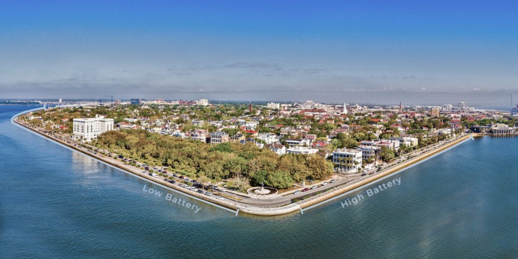
An aerial view of the southern Charleston peninsula from the above the blue water of Charleston Harbor, with a vantage point that appears triangular. The image is annotated to indicate the High Battery along the east side and the Low Battery on the south side.
Annotated orientation image showing the High Battery, White Point Garden, and Low Battery / Murray Boulevard settings.

The High Battery

Historic residences face Charleston Harbor from behind the raised promenade.
Early architecture · Direct harbor views · Highest public visibility
Explore this section

White Point Garden

South Battery homes face White Point Garden, with mature trees and civic space in the foreground.
Park foreground · Shade and depth · Active civic landscape
Explore this section

The Low Battery

Murray Boulevard offers later housing and broad westward views across the Ashley River.
Later housing · Ashley River sunsets · Direct western exposure
Explore this section

The High Battery

A panoramic view of the High Battery from the vantage point of Charleston Harbor with a row of large homes of many colors.

The High Battery is the stretch most people picture when they hear “homes on The Battery.” East Battery Street places a row of prominent historic residences directly opposite the elevated seawall, with broad views across Charleston Harbor toward Fort Sumter, Sullivan’s Island, and the shipping channel.

The architecture is unusually concentrated. Large 18th- and 19th-century residences, Charleston single houses, double houses, piazzas, garden walls, and later additions occupy a relatively short stretch of waterfront. The individual histories vary, but the collective effect is one of Charleston’s most recognizable streetscapes.

That recognition is part of the ownership experience. The promenade is public, and East Battery is one of the most visited parts of the peninsula. Pedestrians routinely pause in front of the houses, architectural tours move through the area, and the view belongs as much to the city as to the residents facing it. Someone seeking complete privacy may find the setting more exposed than the photographs suggest.

The High Battery nevertheless provides the most immediate harbor relationship of the three sections. There is no park or row of houses between the residences and the water – only the street, promenade, and seawall. Upper floors and piazzas can command exceptional views, while the elevated wall provides a measure of separation from everyday tides and wave action.

The houses themselves require more careful comparison than their facades imply. Floor elevation, prior water intrusion, structural condition, masonry, windows, piazzas, roof configuration, mechanical placement, off-street parking, and the practicality of bringing modern systems into a historic building can vary dramatically from one property to the next. A prestigious address does not repeal the laws of building science. It merely makes the repairs more photogenic.

High Battery at a glance

Primary outlook
Charleston Harbor
Typical housing era
18th and 19th centuries
Public realm
Elevated promenade
Defining strength
Direct harbor presence
Main tradeoff
Visibility and historic-building complexity

Listings & recent sales

Active listings and recent sales within the mapped High Battery segment. Inventory is naturally thin; recent sales often explain more than the active market alone.

Homes Facing White Point Garden

A panoramic view of homes on South Battery Street from the vantage point of above White Point Garden with a row of large homes of many colors.

White Point Garden changes the relationship between the houses and the waterfront. The residences along South Battery Street face the park rather than the seawall itself, placing several acres of lawn, pathways, mature trees, and public space between the front doors and the harbor.

That distance creates a different atmosphere. Harbor views are generally more filtered than those along East Battery, but the park provides depth, shade, and a changing landscape rather than an uninterrupted expanse of water. From many homes, the dominant foreground is the live-oak canopy rather than the harbor.

The architectural mix also reflects a broader period of development. Federal, Greek Revival, Victorian, and later alterations appear along the park, often behind formal gardens, masonry walls, ironwork, and deep setbacks. The result feels less like a single architectural procession and more like a collection of substantial city houses gathered around Charleston’s oldest major public park.

White Point Garden is peaceful, but it is not private. It is used throughout the day by walkers, runners, families, tour groups, photographers, small events, and visitors who have no particular reason to whisper. Homes facing the park gain an exceptional public landscape, but they also participate in it.

For a buyer, the practical questions concern the exact position of the property. A home near East Battery experiences the harbor and pedestrian activity differently from one farther west. Tree cover can soften sunlight and views; corner lots may gain exposure and access while sacrificing privacy. Parking, driveways, garden space, first-floor elevation, and the relationship between the principal house and any dependency or carriage house deserve property-specific attention.
White Point Garden at a glance

Primary outlook
White Point Garden and filtered harbor views
Typical housing era
Federal through Victorian, with later alterations
Public realm
Major public park
Defining strength
Shade, depth, and civic landscape
Main tradeoff
Park activity and property-specific sightlines

Listings & recent sales

Active listings and recent sales within the mapped White Point Garden area, where position around the park can matter as much as the street name.

The Low Battery and Murray Boulevard

A panoramic view of the High Battery from the vantage point of Charleston Harbor with a row of large homes of many colors.

Murray Boulevard presents the newest of the three residential settings. Much of the land behind it did not exist in its present form until the early 20th century, when Charleston constructed a new seawall and filled the marsh and riverbed behind it. The first section was built from 1909 to 1911, followed by an eastern extension between 1917 and 1919. The project created approximately 47 acres of new land along the Ashley River.

The resulting homes reflect a later chapter of Charleston architecture. Colonial Revival, Neoclassical, Craftsman, and other early-20th-century influences appear alongside later renovations and occasional replacement construction. Floor plans are often less constrained by the narrow proportions of much older peninsula houses, although age, preservation requirements, and coastal exposure remain very much in the equation.

The Low Battery also faces a different body of water. Its western orientation looks across the Ashley River rather than directly into Charleston Harbor. The views are broad, the afternoon light can be dramatic, and sunsets become part of the daily rhythm. That same orientation also brings direct sun, wind, salt exposure, and weather from across the river.

Murray Boulevard generally feels more residential than East Battery, but the waterfront side remains a public promenade. The street separates the houses from the seawall, and views can be affected by landscaping, parked vehicles, pedestrian activity, wall height, and the elevation of the individual home.

The historic name has become slightly misleading. During the recently completed restoration, the City raised much of the Low Battery wall by approximately 1.8 feet to match the High Battery’s elevation. The Low Battery is no longer especially low; the name survived the engineering.

Low Battery at a glance

Primary outlook
Ashley River
Typical housing era
Early 20th century and later
Public realm
Waterfront promenade
Defining strength
Broad western views and sunsets
Main tradeoff
Sun, wind, salt, and direct coastal exposure

Listings & recent sales

Active listings and recent sales within the mapped Low Battery and Murray Boulevard segment, where western exposure and post-restoration sightlines deserve close attention.
Decision frame

Choosing Among the Three Battery Settings

The useful comparison is not whether one section is better than the others. It is which version of Battery ownership fits the way someone actually wants to live: harbor-facing, park-facing, or Ashley River-facing.

A panoramic view of the High Battery from the vantage point of Charleston Harbor with a row of large homes of many colors.

The High Battery

Direct harbor presence. Best for buyers who want the most recognizable historic streetscape and the fewest layers between the house, the promenade, and the harbor.

Watch: public visibility, preservation review, older building systems, and waterfront maintenance.
A panoramic view of homes on South Battery Street from the vantage point of above White Point Garden with a row of large homes of many colors.

White Point Garden

Park foreground. Best for buyers who prefer shade, mature trees, civic space, and a more layered view rather than water immediately across the street.

Watch: park activity, filtered sightlines, events, parking, and the exact position along South Battery.
A panoramic view of the High Battery from the vantage point of Charleston Harbor with a row of large homes of many colors.

The Low Battery / Murray Boulevard

Ashley River exposure. Best for buyers who want broader western views, later housing stock, sunsets, and a somewhat more residential rhythm.

Watch: afternoon sun, wind, salt exposure, insurance, drainage, and the raised wall's relationship to the house.
The mistake is treating ‘on The Battery’ as one category. It is more like three related waterfront micro-markets wearing the same dinner jacket.

Battery Ownership: What Deserves Real Diligence

A Battery address combines historic architecture, public visibility, coastal exposure, and preservation oversight. The appeal is real. So are the maintenance questions. The goal is not to make the house ordinary; it is to understand what makes it unusually demanding before the closing table starts looking like a confessional.

01

Preservation review

Visible exterior work may require Board of Architectural Review oversight. Ask what has already been approved before assuming what can be changed.
02

Hidden building systems

Foundations, piazzas, masonry, roofs, drainage, wiring, plumbing, and mechanicals often matter more than the facade.
03

Flooding and drainage

The seawall is infrastructure, not a parcel-level guarantee. Elevation, flood history, drainage, and lower-level spaces must be evaluated house by house.
04

Insurance profile

Quotes should be obtained early. Construction type, roof age, systems, prior claims, flood elevation, and replacement cost can shift the numbers quickly.
05

Public realm

The promenade, park, and street are part of the experience. Visit at different times, not just during the flattering hour when even a parking meter looks historic.
06

Parking and access

Driveways, gates, garages, rear access, deliveries, contractors, storm prep, and guest parking are daily-life issues, not footnotes.

A better showing question

Do not ask only whether the house is on The Battery. Ask how this specific house handles water, visibility, preservation, parking, insurance, and maintenance. That is where the address becomes a property.

How Charleston Built — and Rebuilt — The Battery

The Battery is not one natural edge of the peninsula. It is a series of defenses, fills, promenades, parks, reclaimed land, and modern public works pretending, rather convincingly, to have been inevitable.

For this guide, the history matters because it explains why the three residential settings feel so different. East Battery grew from early harbor defenses and an elevated seawall. White Point Garden developed around filled land and a public park. Murray Boulevard came later, after Charleston pushed a new wall into the Ashley River and created new residential land behind it.

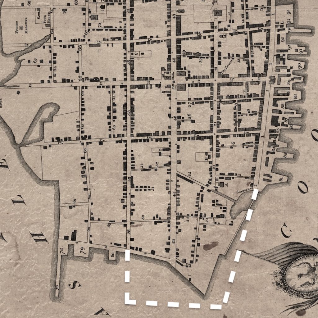
A 1739 map of Charles Town indicating the structure of the Battery
Charles Town 1739
1680s–1760s

Colonial defenses

The southern edge began as a vulnerable shoreline protected by early fortifications, batteries, and storm-battered defensive works.
A 1788 map of Charleston indicating the proposed seawall for the Battery
Proposed seawall for The Battery
1790s–1818

The High Battery

Charleston built outward into the Cooper River, creating a stronger seawall, promenade, and the setting that shaped East Battery.
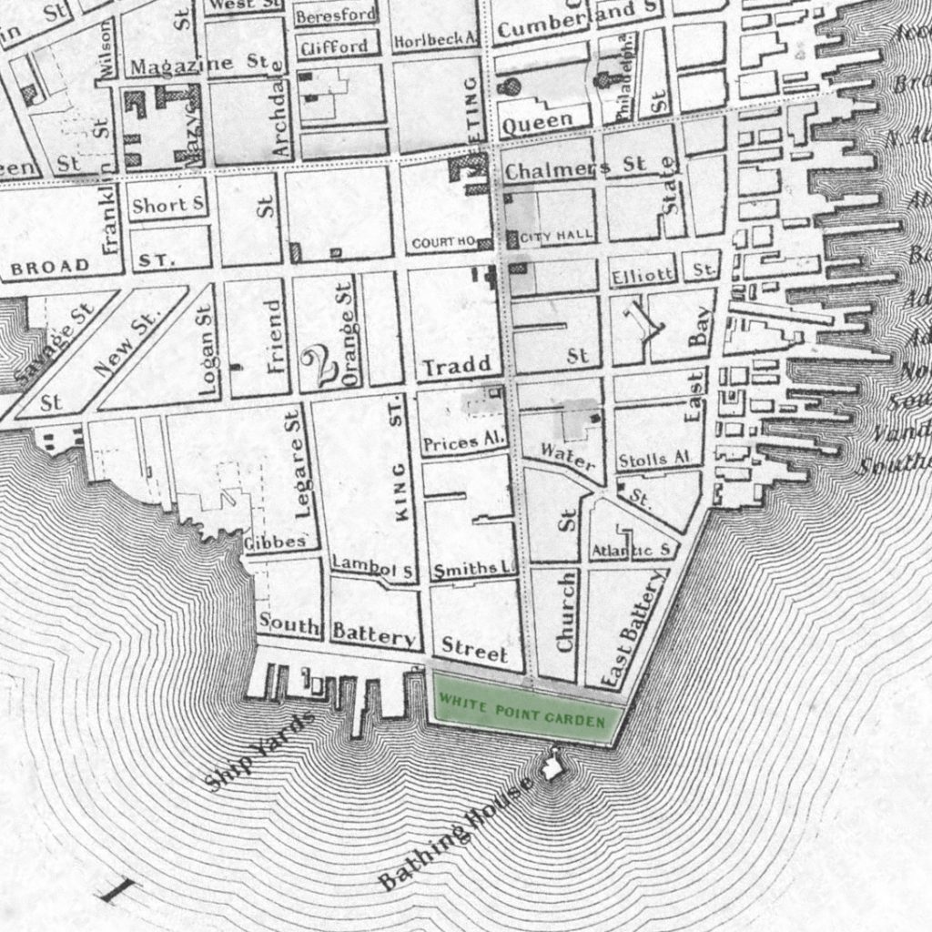
A 1859 map of Charleston indicating the newly built White Point Garden
White Point Garden in 1859
1830s–1850s

White Point Garden

Filled land and public improvements turned the southern tip into a civic landscape, changing the outlook for South Battery homes.
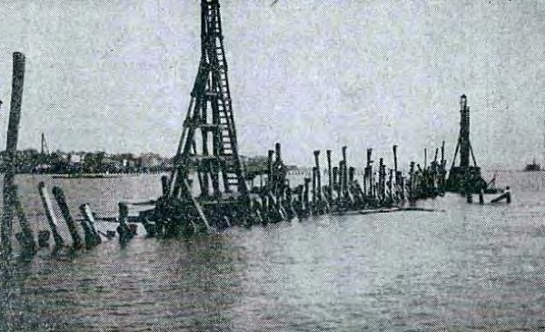
Construction of the Low Battery in 1909
1909–1919

The Low Battery

The Boulevard Project extended a new wall into the Ashley River, filled land behind it, and made Murray Boulevard possible.

The modern infrastructure chapter

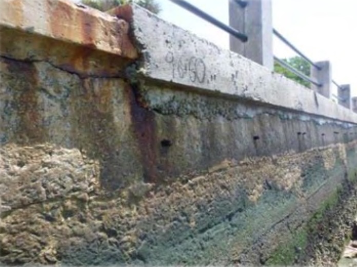
The Low Battery restoration began in 2019 and was formally completed in February 2026. The project rebuilt nearly 5,000 feet of waterfront, raised much of the wall, widened the public promenade, improved drainage, added check valves and water-quality structures, and updated crossings, utilities, parking, landscaping, and ADA access.

That does not make Battery ownership risk-free. It does mean the most visibly fragile part of the old Low Battery has been replaced by infrastructure designed for modern coastal conditions. The view is still historic; the machinery underneath it is less antique.

  • Stronger seawall and modern foundation
  • Higher wall along much of Murray Boulevard
  • Wider, ADA-compliant promenade
  • Improved drainage capacity and tidal check valves

Three Sections, Three Ownership Experiences

There is no universally preferable section of The Battery.

The High Battery offers the most direct harbor presence and the greatest concentration of early architecture, along with substantial public visibility.

White Point Garden provides a park as its foreground, trading some immediacy of the water for shade, depth, and a more layered view.

The Low Battery offers later housing, broad Ashley River views, and a somewhat more residential rhythm, together with western sun and direct coastal exposure.

The useful question is not simply whether a house is “on The Battery.” It is which Battery experience the house provides – and what that particular property will ask of its owner.

Considering a home along The Battery?

A property’s location, elevation, condition, preservation history, insurance profile, and relationship to the public waterfront matter more than the address alone.