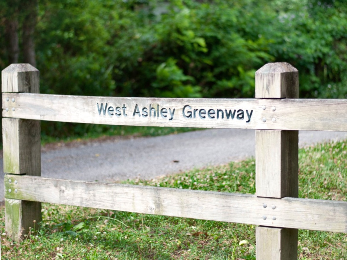
The West Ashley Greenway
The West Ashley Greenway is one of Charleston’s better examples of useful restraint: a former rail corridor turned into a long, practical public path without requiring anyone to pretend it is a lifestyle brand. It runs across West Ashley from the Main Road side toward Folly Road, moving through marsh edges, neighborhoods, shopping areas, and the less-photographed places where daily life actually happens.
That is the point. The Greenway is not merely a place to walk the dog, though it is certainly qualified for that highly competitive civic assignment. It is a piece of connective tissue in a part of Charleston where the road network often behaves as if every errand should require a steering wheel, a left-turn prayer, and a generous emotional cushion.
A trail that works harder than it looks
Most Charleston amenities announce themselves. The West Ashley Greenway does not. It slips behind shopping centers, crosses residential streets, brushes past marshes, and gives West Ashley a linear route that is calmer than Savannah Highway and more useful than another beautified median.
The original article framed the Greenway through the rails-to-trails movement, which remains the right starting point. Old rail corridors are unusually good raw material for public space because they were designed to go somewhere. They cut across the map with a logic that predates the subdivision entrance, the strip-center curb cut, and the modern Charleston habit of making simple travel unnecessarily theatrical.
The Greenway matters because it turns a leftover transportation corridor into a usable civic route. That is a different category from “nice outdoor amenity,” and frankly a more important one.
West Ashley Greenway at a glance
Runs across West Ashley from the Main Road / Johns Island side toward Folly Road and South Windermere.
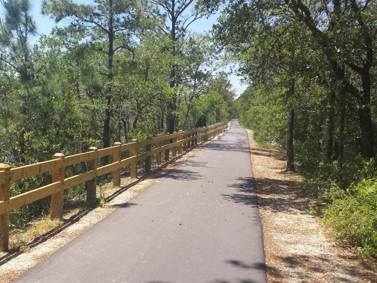
Commonly described as about 10.5 miles, though some official planning materials refer to the leased city park segment as roughly eight miles.
A mix of paved portions and hard-packed dirt, generally flat and approachable for walking and biking.
A recreational path, yes, but also a serious off-street mobility corridor for West Ashley.
From rail corridor to public corridor
The elevated path through parts of West Ashley traces back to the Atlantic Coast Line Railroad, a corridor built for movement rather than scenery. Agricultural products, passengers, and freight once moved through this landscape with a directness that modern local roads rarely manage.
By the late twentieth century, this portion of the rail line had outlived its original job. The useful part was not the rails themselves, but the corridor they left behind. In the 1990s, that corridor was repurposed into the Greenway as part of the broader rails-to-trails movement: a practical reuse of land that might otherwise have been chopped up, forgotten, or smothered under the usual collection of asphalt afterthoughts.
That history matters because the Greenway is not accidental open space. It is infrastructure being asked to perform a second act. In Charleston, where the built environment rarely misses an opportunity to complicate movement, that is no small thing.

The route is the argument
On a map, the Greenway explains itself better than any brochure language could. It runs across West Ashley in a way that roads and subdivisions do not, creating a route that ties together places usually treated as separate pockets.

How the Greenway connects West Ashley
West Ashley is not one tidy place. It is a collection of older neighborhoods, commercial corridors, marsh edges, postwar subdivisions, newer development, and roads that have spent decades absorbing more traffic than grace. The Greenway cuts through that fragmentation with something rare: a route that is not primarily designed around cars.
That does not mean it solves West Ashley’s mobility problems. Let’s not get carried away; this is Charleston, not Copenhagen with shrimp and grits. But it gives residents a useful alternative for short trips, exercise, and neighborhood-to-neighborhood movement.
South Windermere and Folly Road
Eastern access near shopping, restaurants, and daily errands, which is the difference between a trail and a useful trail.
Neighborhood access
Multiple entry points let nearby residents use the Greenway without making an event of it.
Parks and civic spaces
Ackerman Park and related recreational areas benefit from the Greenway’s linear access.
Marsh and rural edges
The western portions feel more open, with creeks, wetlands, and a stronger sense of leaving the retail corridor behind.
What it means for nearby real estate
For real estate, the Greenway is best understood as a neighborhood amenity with uneven but meaningful influence. A home near the trail may gain practical appeal from walkability, outdoor access, and a stronger sense of connection to the surrounding area. That is especially true in parts of West Ashley where the alternative is a car trip for almost everything, including things that should not require a car trip unless one is being punished.
But proximity is not magic. A house near a pleasant access point is different from a house backing directly onto a busier stretch with privacy concerns. A short, intuitive walk to South Windermere is different from theoretical access across a road that behaves like it was designed by someone with a personal grudge against pedestrians.
The Greenway can add value, but the better question is how it changes daily use. Does it make the property more connected? Does it improve the morning routine, the dog walk, the bike ride, the errand? Or is it merely nearby in the same way the moon is nearby?
The practical question is not whether Greenway proximity is good. It usually is. The question is whether that proximity is usable, pleasant, and properly matched to the property.
- Direct access can improve day-to-day livability.
- Backing onto the trail can raise privacy and noise considerations.
- Nearby access is most valuable when it connects to errands, parks, or other useful destinations.
- Market impact varies by neighborhood, price point, and the quality of the specific access.
The Greenway and the Bikeway should be read together
The original page paired the Greenway with the Maryville Bikeway, and that instinct was right. These linear parks matter most when they begin to form a network rather than a collection of isolated recreational strips.
The Bikeway helps connect neighborhoods closer to the Ashley River side of West Ashley, while the Greenway carries the longer east-west movement. Together, they hint at what West Ashley could have more of: routes that let people move between neighborhoods, parks, schools, and commercial areas without treating every trip as a negotiation with traffic.
This is where the planning language can sound painfully bland—“multi-modal connectivity,” “placemaking,” and other phrases that make perfectly good ideas wear khakis. The simpler version is better: people need safe, pleasant ways to get around without always driving.
The future is probably incremental—and that is not an insult
The future of the West Ashley Greenway should be discussed carefully. There are master plans, improvement concepts, public art ideas, better signage, crossing improvements, and broader regional mobility dreams. Some of those ideas are visible now. Others will move at the traditional civic pace, which is to say somewhere between “measured” and “did the committee go into hibernation?”
That does not make the plans unimportant. It makes the practical pieces more important. Improved crossings can change whether the trail feels comfortable to use. Better wayfinding can make the Greenway legible to people who do not already know it. Amenity stations, shade, seating, water, restrooms, and safer access points are not cosmetic details; they determine whether the Greenway functions as serious public infrastructure or just a long nice thing that people use when conditions happen to cooperate.
The Greenway does not need to become overdesigned. Its charm is partly that it still feels a little informal in places. But informality should not be confused with neglect. The goal is not to polish it into a theme park trail. The goal is to make it safer, clearer, more connected, and more useful.
Planning Note: The strongest future version of the Greenway is not just longer. It is easier to enter, safer to cross, clearer to navigate, and better connected to the places West Ashley residents already use.
Why this matters to Charleston livability
West Ashley has long been treated as Charleston’s practical side: where people live, shop, commute, raise families, and endure Savannah Highway with the stoicism of minor saints. The Greenway complicates that lazy description. It shows that West Ashley also has the bones for better public space, better everyday movement, and more connected neighborhoods.
That matters for buyers, sellers, residents, and planners. For buyers, the Greenway can change the lived experience of a home. For sellers, it can be part of the property’s story when the access is meaningful. For residents, it is simply useful, which remains an underrated virtue in civic design.
The West Ashley Greenway is not perfect, and that is fine. Perfect public spaces tend to exist mostly in renderings, where nobody sweats, traffic is implied rather than heard, and every family appears to own exactly one golden retriever. The real Greenway is more interesting. It is a working piece of Charleston: a little uneven, quietly valuable, and still capable of becoming much better.
View homes near the Greenway
Greenway proximity is worth considering, but it should be evaluated property by property. The useful question is not whether a home is near the trail. The useful question is whether the trail meaningfully improves the way that home lives.