Rethinking Coleman Boulevard
Mount Pleasant has an Old Village, several commercial centers, and plenty of traffic. What it has not always had is an obvious civic main street. Coleman Boulevard is the town’s long-running attempt to build one.
People had opinions about this.

A Town Center – sort of
Mount Pleasant did not begin as one compact village. The town was assembled from several small settlements around Shem Creek and Charleston Harbor, with what we now call Old Village preserving the clearest piece of that traditional town fabric.
Postwar growth did not simply extend that old street grid. Homes and commercial centers spread across former farmland in the familiar suburban pattern: subdivisions connected to feeder roads, feeder roads connected to larger arterials, and daily destinations increasingly separated from one another.
That growth produced plenty of recognizable neighborhoods, but no single downtown that grew along with the town. Coleman Boulevard eventually became the most plausible place to try to make one.
Growth without a downtown
Before Coleman
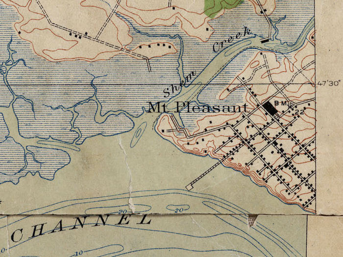
The corridor makes more sense when it is read as a transportation history. Ferries, the coastal road, the first Cooper River Bridge, postwar widening, and finally the Highway 17 bypass each changed where people moved — and where commerce followed.
Old Village

Georgetown Road

Coleman Boulevard

In the mid-1960s, the Pearman Bridge and a new U.S. 17 bypass redirected much of the through traffic away from Coleman. Commercial growth followed the newer highway, and Coleman entered the next few decades as an older business corridor rather than the obvious route through town.
Main Street by Accident
Coleman Boulevard was never quite integrated into Old Village, never quite provided the throughput of Highway 17, and ballooned into such a width that actively prevents a natural traditional downtown from growing anyway. It became Mount Pleasant’s commercial spine because transportation patterns put businesses there, not because anyone ever created a cohesive plan for expanding Old Village into a growing town center.
That left Coleman Boulevard trying to do two different jobs. It needed to move traffic across town while also serving shops, homes, schools, restaurants, and people on foot or bicycle. Urbanists sometimes call that kind of hybrid a stroad: part road, part street, and not particularly great with either role.
The revitalization did not eliminate that conflict. It began deciding where the street function – crossings, frontage, public space, slower local access – needed more room to exist.
Streetscaping
By the 2000s, Coleman read mostly as a broad commercial corridor like a million others: shopping centers, stand-alone businesses, frequent driveways, a large center-turn area, and sidewalks that existed without adding up to a comfortable pedestrian system.
Streetscaping is useful here because the Coleman project was not just decorative lamps and landscaping. Between Mill Street and Pherigo Street, the town rebuilt stormwater, roadway, and utilities; added adaptive signals and transit amenities; expanded bicycle and pedestrian facilities; installed wayfinding and landscaped medians; and created a more deliberate public edge between the road and the buildings along it.
Public Realm
Movement
Infrastructure
Redevelopment
The Street Section
Street design is behavior design. The revised section did not turn Coleman into a quiet neighborhood street, but it replaced some of the old corridor ambiguity with more channelized movement, clearer crossings, defined bicycle and pedestrian space, and a more deliberate public edge.


Before / After
These comparisons make the case more clearly than another page of adjectives. None of the individual changes is especially theatrical. Together, the medians, lighting, planting, crossings, and lane definition alter what the street asks drivers and pedestrians to do.


Pushback
The argument started well before the construction barrels. At a 2012 public hearing, residents and business owners debated a plan that would keep Coleman at four lanes while adding landscaped medians, bicycle facilities, sidewalks, and limited parallel parking. Business access was the recurring practical concern: once the continuous center-turn condition becomes a median, individual properties no longer receive every possible left turn.
The land-use concern arrived with equal force. Mixed-use redevelopment along Coleman was presented as a step toward a pedestrian-oriented main street. Critics saw the same projects as evidence that “revitalization” could also mean more traffic, taller buildings, and a different version of Mount Pleasant than the one they thought they were protecting.
That is the useful lesson. The dispute was never simply about sidewalks. Coleman became the place where Mount Pleasant argued about whether a suburban commercial corridor should remain mostly car-oriented, or whether it should become the footprint for a more complete town center.
A Better Footprint
This is why I think Coleman matters. The project did not manufacture a traditional downtown, and it could not have done so by itself. What it did was create a better footprint: infrastructure that can support redevelopment, a more legible public realm, and a street edge that new buildings can actually address.
In New Urbanist terms, this resembles suburban retrofit — adding pieces of walkable urbanism to a place that was largely shaped around automobile access. Most postwar suburbs are organized in the opposite direction, with local streets and cul-de-sacs feeding collectors and arterials while homes, shops, schools, and offices occupy separate parcels. That pattern is familiar, but it does not readily produce a civic center on its own.
Coleman is interesting because Mount Pleasant tried to graft some of that missing town structure back onto an existing commercial corridor rather than starting with a blank sheet.
2017 → 2020
These aerials bracket the main construction period and its immediate aftermath. The physical change was happening at the same time residents were arguing about what kinds of development the rebuilt corridor might invite.


Stormwater
One of the least photogenic parts of the project may be one of the most consequential. Town project materials said Phases 1 and 2 would treat runoff from 24.32 acres that had previously discharged untreated into the Shem Creek watershed, and public meeting records describe the new drainage system as treating stormwater before discharge into the creek.
That is an important Lowcountry correction to the word “streetscaping.” The road is also part of a watershed. Sidewalks, medians, utilities, drainage, and water quality are not separate projects simply because they occupy different lines in a budget.

Living Around Coleman
The built-form argument is easier to understand when you look at the housing around the corridor. Old Mount Pleasant still contains the inherited village pattern of detached houses on smaller connected streets. Coleman and the nearby blocks add a different pattern of apartments, condominiums, townhomes, and other attached housing closer to shops and services.
The two live collections below are examples of current inventory inside the canonical Old Mount Pleasant area. They are not a claim that every property shown fronts Coleman Boulevard.
Detached Homes


Condos & Attached Homes


What Coleman Became
By the 2019 comprehensive-plan process, Mount Pleasant was already acknowledging that the earlier corridor overlay had not produced exactly what the town expected. The current code still favors pedestrian-oriented form, but with more specific controls on scale and building placement. That is a more useful description of what happened than saying the town simply embraced or rejected urbanization.
Coleman did not become a traditional downtown. I think its more durable achievement is the footprint: a corridor with more of the infrastructure, public realm, and development logic required for a real center to accumulate over time. That is what suburban retrofit often looks like in practice — not an instant downtown, but a place gradually made capable of supporting more complete urban life.
A later step came in 2025, when marked bike lanes across the Shem Creek Bridge closed a gap and created more than 1.5 miles of continuous bike lanes along Coleman from Houston Northcutt Boulevard to Pherigo Street. The street is not finished, which is probably the right condition for a main street anyway.