Walkable Neighborhoods in Charleston
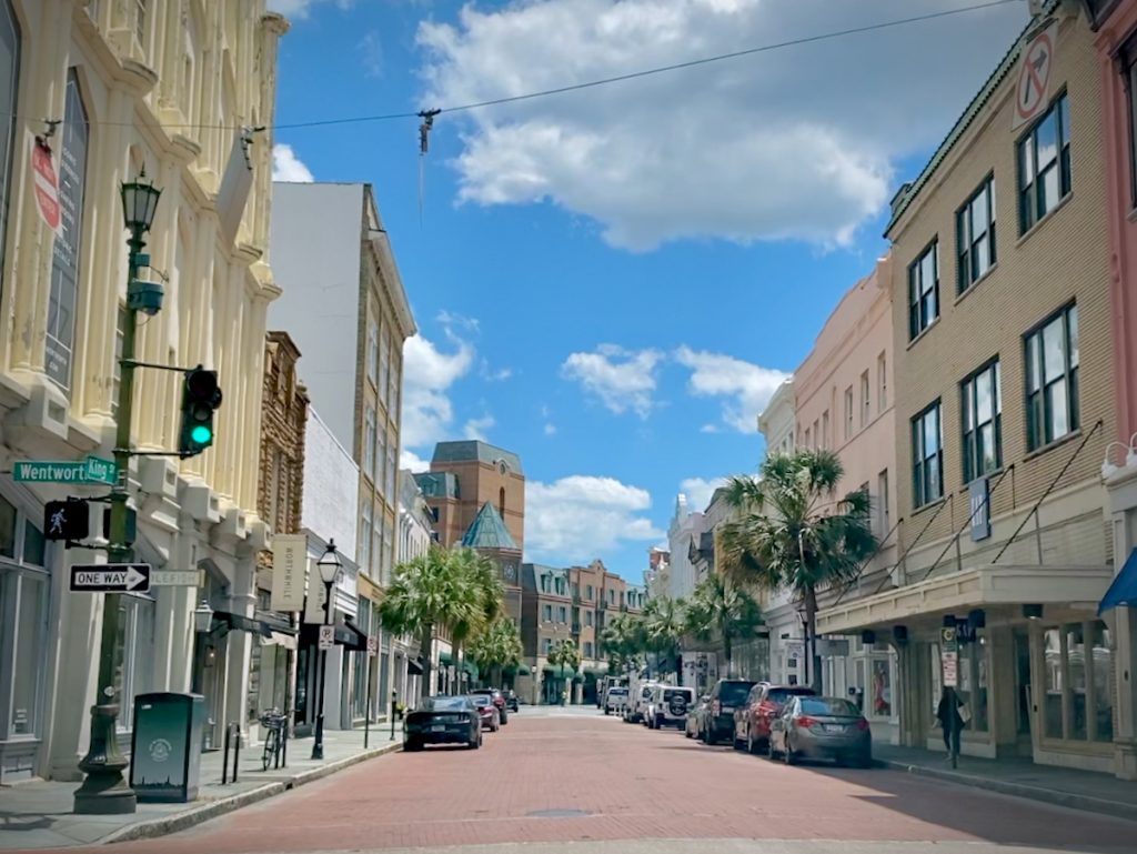
Benchmark: Historic Charleston
The Charleston Peninsula remains the region’s clearest example of walkability that evolved over time: short blocks, frequent intersections, shops and civic uses mixed among homes, and enough daily activity that a street can perform several jobs at once.
The neighborhoods in this article do not reproduce that pattern exactly, nor should they. Some offer a compact village center. Others organize parks, trails, schools, or commercial destinations more deliberately. Folly Beach offers something else again. The useful question is not whether each place feels like downtown, but which parts of the pattern would improve the life you actually intend to live.
For the larger history of how Charleston developed, abandoned, and later began rebuilding these ideas, read Walkability in Charleston.
Find your bearings
These neighborhoods are not interchangeable. Some make ordinary errands easier. Some are strongest around a compact village center. Others were planned with parks, trails, schools, and internal destinations from the beginning. And some are mostly excellent places to walk once you are already there.
What walking actually accomplishes
Everyday errands
A walkable center
Designed connections
Walking for pleasure
Old Village
Old Village is one of the clearest examples outside the Charleston Peninsula of a walkable pattern that developed over time. Pitt Street, small shops, churches, parks, waterfront access, and quiet residential streets sit close enough together that the area still feels like a village rather than a subdivision with a historic nickname.
The practical benefit depends heavily on the specific address. A home near Pitt Street can support a very different routine from one farther toward the edge, and most regional errands still require a car. The appeal is real, but it is not evenly distributed across every block that borrows the name.
Old Village is strongest for buyers who want a historic village setting, local character, and a quieter coastal rhythm. It is also one of the places where the premium for a long-established walkable setting is not theoretical.

Homes for Sale in Old Village


Park Circle
Park Circle works because it has a recognizable civic and commercial center. The central park, East Montague corridor, connected residential streets, and continuing investment in public space give the neighborhood a structure many suburban areas simply do not have.
The usefulness changes by block, crossing, and distance from the center. But when the pieces line up, Park Circle offers one of the Charleston area’s more convincing village routines without pretending every daily errand has become car-free.
Park Circle is a strong fit for buyers who want local restaurants, older-house character, parks, and an actual neighborhood center—without needing to claim that the car has been abolished.

Homes for Sale in Park Circle


Avondale
Avondale is walkable in a concentrated, distinctly West Ashley way. Its commercial district gives nearby residents a real destination for dining, coffee, and social life, while the surrounding residential streets keep the center from feeling like an isolated shopping strip.
The West Ashley Greenway adds recreational and bicycle value. Savannah Highway and the surrounding automobile-oriented pattern still impose the usual limits. Avondale is best understood as a compact village node within a much larger car-dependent part of town.
Avondale is most convincing when the house is genuinely connected to the commercial district or Greenway. A few blocks can change the value of the entire idea.

Homes for Sale in Avondale


Downtown Summerville
Downtown Summerville offers a different version of walkability: a historic small-town core with shops, restaurants, civic spaces, and older homes arranged around a recognizable center. Hutchinson Square gives the area a public anchor, and the surrounding streets support a more traditional daily routine than most of the suburban growth around it.
The boundary matters. Inside the historic core, walking can feel natural and useful. Beyond it, the broader suburban pattern returns rather quickly—which is not a criticism so much as a reminder to look closely at the address.
Downtown Summerville is strongest for buyers who want small-town walkability and historic character, while accepting that much of the surrounding area still functions like suburbia.

Homes for Sale in Downtown Summerville


I’On
I’On is one of the clearest examples in the Charleston area of a neighborhood deliberately designed around walking and public space. Its connected streets, public squares, neighborhood center, lakes, paths, and varied housing forms were intended to recover some of the usefulness and civic character of older towns.
That design has become part of the community’s value. I’On is not the more attainable version of walkable Charleston; it is one of the premium examples. For buyers who want that particular combination of public realm, architecture, and neighborhood identity, it deserves close attention.
I’On is the obvious place to study if you want to see traditional neighborhood design carried through with conviction. The remaining question is whether the premium, location, and housing style fit the rest of the search.

Homes for Sale in I’On


Search by the Kind of Place You Want
The right answer may be a premium historic village, a planned town, a beach community, or a less famous street that simply connects to the things you use every week. That is where a broad search portal usually becomes a blunt instrument.
Daniel Island
Daniel Island is less a single walkable neighborhood than a planned town containing several centers, districts, parks, trails, schools, offices, and waterfront places. That scale gives it more internal variety than a village, but it also makes the exact location of the home more important.
A property near the town center, a school, a park, or the trail network may support a very different routine from one elsewhere on the island. Daniel Island can reduce some daily driving within the community. Most regional trips, naturally enough, still begin by car.
Daniel Island is best evaluated district by district. The broad community label matters, but the daily-life question is always what a specific address connects to comfortably.

Homes for Sale in Daniel Island


Carnes Crossroads
Carnes Crossroads represents a newer generation of connected suburban planning. Rather than trying to imitate Downtown Charleston, it places parks, lakes, trails, schools, healthcare, neighborhood amenities, and commercial areas within a larger planned setting.
It should not be judged by whether it behaves like a historic downtown; that was never the assignment. Its stronger argument is that suburban development can provide more internal connections and more reasons to walk or bike, even when the wider regional trip still involves a freeway.
Carnes Crossroads is most compelling for buyers who want newer homes, internal amenities, trails, and a more connected plan than the usual subdivision pattern. Exact home location still matters.
Homes for Sale in Carnes Crossroads


Folly Beach
Folly Beach is walkable in the beach-town sense: Center Street, restaurants, bars, beach access, and recreational life are gathered within a compact island setting. For some buyers, that is precisely the point. The routine is less about completing errands on foot and more about living close to the water and the island’s social center.
The tradeoffs arrive with the scenery. Seasonal traffic, parking, storms, insurance, and limited everyday services all shape the experience. Folly is not complete daily-needs walkability; it is a very specific coastal version of a car-light life.
Folly works when beach access and island life are the main walkable destinations. It is not the place to pretend grocery runs and mainland appointments have disappeared.

Homes for Sale in Folly Beach


Frequently asked questions
Which Charleston-area neighborhood is the most walkable?
Downtown Charleston has the deepest daily-use walkability, but this article focuses on the more useful buyer question: which places offer a meaningful version of walkability for a specific routine, budget, and housing preference. Old Village, Park Circle, Avondale, I’On, Daniel Island, Downtown Summerville, Carnes Crossroads, and Folly Beach all offer different forms of the idea.
Can you live in Charleston without a car?
In limited parts of the Peninsula, some residents can live with very little car use. Across most of the region, a car remains difficult to avoid. Several neighborhoods can reduce the number of trips by car, or make one-car household living more plausible, but complete car-free living is still the exception.
Are planned communities like I’On and Daniel Island actually walkable?
They can be, but in different ways. I’On is a more compact neighborhood-scale example with a village center and connected public realm. Daniel Island is larger and more district-based, with trails, parks, schools, and commercial areas spread across a planned town. In both cases, the exact home location matters.
Are newer communities like Carnes Crossroads walkable?
Carnes Crossroads is better understood as connected suburban design. It offers internal destinations, trails, parks, schools, healthcare, and amenities in a more intentional pattern than a conventional subdivision. That does not make it a historic downtown, but it can still reduce the friction of daily life within the community.
Why are many walkable neighborhoods expensive?
Scarcity. Connected streets, mature public space, nearby destinations, and recognizable neighborhood identity are hard to create quickly. The most complete examples tend to command a premium. That does not mean every buyer needs the full package; sometimes a more focused version of walkability is the better fit.
How should I evaluate a specific house for walkability?
Trace the routes you would actually use: dinner, groceries, school, parks, beach access, trails, or coffee. Check crossings, shade, sidewalk continuity, traffic speed, drainage, and how the route feels in less convenient weather. A neighborhood can be broadly walkable while a particular address is not.
Find the place that fits
A walkable neighborhood is only useful if it supports the way you actually live. If you want help comparing these places against budget, commute, housing style, and daily routine, we can narrow the field before the search turns into a very scenic spreadsheet.