Walkability in Charleston

Charleston's walkable places did not come from one planning theory or one era. Some evolved before the automobile, some survived around village centers, and others were built later by people trying – sometimes quite deliberately – to recover the same useful pattern.
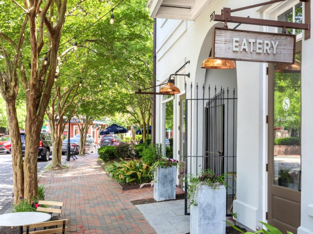
Shops with a white stucco finish lining a street in the I'On neighborhood with one sign that reads "Eatery." Along the left is a row of crepe myrtle trees with full green canopies shading the red brick sidewalk.

Walk down King Street and stop at a bakery you had not planned to visit. It is a small pleasure, but one that hints at a larger truth: life feels more connected, and a little less scheduled, when some part of it happens outside the confines of a car.

There was a time when neighborhoods like this did not need a label. They simply reflected the way towns and villages accumulated before modern zoning separated homes from shops, schools from errands, and nearly everything from nearly everything else. The names we now use – mixed-use, traditional neighborhood design, New Urbanism – may be recent, but the fundamental ideas behind them are not.

Charleston has repeated the same basic idea in several forms. Downtown Charleston and Old Village developed it gradually. Park Circle and Avondale preserved smaller village centers through the automobile age. I’On reconstructed the pattern deliberately. Daniel Island, Nexton, and Carnes Crossroads expanded it across larger planned communities. Elsewhere, greenways, safer crossings, and Complete Streets projects are trying to reconnect places already built.

LOOKING FOR SPECIFIC PLACES TO LIVE?

The companion Walkable Neighborhoods in Charleston article compares particular places, their tradeoffs, maps, and live listings. This guide explains the larger history and design logic behind them.

Before the Label

Downtown Charleston and Old Village Mount Pleasant are not identical places, but both developed before automobile access became the main organizing principle. Their streets had to connect ordinary life because ordinary life had no alternative.

The skyline of Charleston as viewed from South Battery Street, showing grand homes facing large green oak trees against a blue sky with clouds.

Downtown Charleston

Charleston’s peninsula contains the region’s deepest concentration of walkability that evolved over time: short blocks, frequent intersections, shops and civic uses mixed among homes, and enough activity that a street can perform several jobs at once.

That accumulated convenience is not the same thing as perfection. Tourism pressure, flooding, parking, older buildings, delivery traffic, and uneven bicycle conditions are part of the experience. Even the region’s most naturally walkable streets still require modern work – traffic calming, drainage, accessibility, and the occasional reminder that a crosswalk is not decorative paving.

Old Village Mount Pleasant

Old Village grew from Mount Pleasant’s early settlements into a compact coastal village where residential streets, Pitt Street businesses, churches, parks, and waterfront access remain close together. It offers a quieter version of the same older walkable pattern found on the peninsula.

The benefit is highly location-sensitive. A home near Pitt Street can support a different routine from one farther toward the edge, and many regional errands still require crossing beyond the village. The form works; it simply does not pretend the rest of Mount Pleasant disappeared.

WHAT THE MARKET IS REALLY BUYING

In the oldest walkable districts, buyers are not paying only for proximity to restaurants. They are buying a street network, mature public realm, architectural variety, and the accumulated convenience of a place that has had generations to become itself. Scarcity makes that expensive, which is obvious enough; less obvious is that a buyer may value only part of the package.

Village Design

The rise of the automobile did not erase every village pattern at once. Park Circle and Avondale show how a recognizable center can survive inside a much more car-dependent regional system.

Park Circle

Planned in the early twentieth century around a central circular park, Park Circle carried City Beautiful and garden community ideas into what became North Charleston. The plan gave the neighborhood a civic anchor, connected streets, and a legible center long before East Montague Avenue became the dining and retail corridor it is today.

Recent reinvestment in the central park has strengthened the public realm, but Park Circle’s usefulness still changes by block. Being near the circle, the commercial strip, or a comfortable crossing is different from merely living somewhere inside the broad area now sold under the same name.

Avondale

Avondale offers a different midcentury version of village life. Its compact commercial district sits beside established residential streets, creating a strong social and dining center without becoming a complete car-free district.

The West Ashley Greenway adds recreational and bicycle value, while Savannah Highway and the surrounding suburban pattern impose the usual limits. The result is concentrated walkability: very useful when the specific home connects to the center, much less persuasive when a major road or long detour intervenes.

A house near the center and one at the edge of the same named area can support entirely different routines. Search portals tend to flatten that distinction. Buyers live it.

FIRST-GENERATION NEW URBANISM

Rebuilding the Pattern

I’On marked a local shift from walkability that had developed over generations to a neighborhood deliberately designed around walking and public space. Its 1990s plan used connected streets, small blocks, public squares, varied housing, civic sites, and a neighborhood center to challenge the conventional Mount Pleasant subdivision pattern around it.

The point was not historical reenactment. It was to make the public realm useful again: create several routes, frame gathering places, and give residents reasons to move through the neighborhood without every trip beginning at the garage door.

The market understood the result quickly. I’On became one of the region’s premium communities – evidence both that the design worked and that connected places remained scarce.

Connected streets

Routes disperse rather than funneling every trip onto one collector road.

Civic spaces

Squares, lakes, churches, and common spaces help organize community life.

Mixed housing

Different building types create variety without treating every block as a separate product.

Village center

A modest commercial core gives walking an actual destination.
SUCCESS HAS A PRICE

I’On proved that the market valued traditional neighborhood design. It also became evidence that when connected places are scarce, access to them can become expensive. Many buyers do not need to be persuaded that the lifestyle is appealing; they need help finding where some version of it exists at a price that fits the rest of their life.

Building a Town

Daniel Island expanded the New Urbanist idea from neighborhood composition into something closer to town-building. The planning challenge was no longer one square and one center, but a much larger system of districts, schools, offices, parks, trails, waterfront areas, and commercial destinations.

Several centers

Different districts serve different routines; the island does not operate as one uniform walkable zone.

Civic and family life

Schools, parks, recreation, and community facilities make the plan more complete than a purely residential subdivision.

Trails and waterfront

Internal paths and public spaces create continuity, while regional trips still often require a car.

Scale changes the experience. A town-sized plan can provide a wider range of homes, parks, schools, trails, and commercial destinations, but it also makes exact location more important. A home near the town center or trail network may support a different routine from one several districts away.

Daniel Island is therefore not simply walkable or not walkable. It contains several versions of internal access within a community still connected to the larger region primarily by road. The useful question is what a particular address reaches comfortably.

LARGER NETWORKS, NEWER HOMES

The Next Generation

Nexton and Carnes Crossroads represent a newer phase. The ambition is less about recreating one picturesque village and more about building a distributed network of neighborhoods, schools, healthcare, trails, recreation, employment, and commercial centers across a much larger suburban landscape.

Nexton

Nexton approaches placemaking at town scale, with multiple neighborhoods, parks, trails, schools, offices, retail, and dining developing around the I-26 and 17A growth corridor. Its newer homes and broad housing mix widen the choices beyond one architectural type or price tier.

The tradeoff is maturity. Some parts already have a strong network of destinations; others are still growing into the plan. Buyers should distinguish what exists today from what appears on the long-range map.

Carnes Crossroads

Carnes Crossroads uses traditional-neighborhood ideas within a large suburban setting near Summerville and Goose Creek. Parks, lakes, trails, schools, healthcare, and commercial areas are intended to give residents more internal destinations than a conventional subdivision usually provides.

It should not be judged by whether it behaves like a historic downtown; that was never the assignment. Its stronger argument is that suburban development can provide more internal connections and more reasons to walk or bike, even when the wider regional trip still involves a freeway.

BUYING THE PLAN OR BUYING THE PLACE

In a growing master-planned community, buyers should separate the experience that exists today from the one shown on the long-range plan. Both matter, but they should not be given the same weight. Some buyers enjoy arriving early; others would rather buy the finished sentence.

Repairing the Gaps

Most of metropolitan Charleston will not be rebuilt as a New Urbanist community. The larger task is to make existing places incrementally more useful: connect a trail, repair a sidewalk gap, shorten a crossing, slow a turn, add shade, or make a bus stop feel like somewhere a person was expected to stand.

Linear corridors

The West Ashley Greenway, Bikeway connections, and proposed Lowcountry Lowline begin with a useful premise: a linear corridor can connect neighborhoods rather than divide them. The route itself is only part of the job. Access points, crossings, lighting, shade, and actual destinations determine whether it becomes transportation or merely pleasant recreation.

Read: West Ashley Greenway →Follow: Lowcountry Lowline →

Complete Streets

Complete Streets is planning language for a fairly ordinary proposition: roads should account for people walking, cycling, waiting for transit, crossing with children, or moving with limited mobility – not only people passing through in cars. Medians, shorter crossings, slower turns, sidewalks, bike space, trees, and drainage often matter more than one dramatic project.

Project reality

A concept is not approval; approval is not funding; funding is not construction; and construction is not the same thing as being able to walk across it on Tuesday morning. Future connectivity can matter to a buyer, but present conditions should carry more weight than a rendering.

PRESENT TENSE FIRST

A future trail or safer crossing may improve a location, but a buyer still has to live with the route that exists on closing day.

Homebuyers look for it

Across these eras, the market has been remarkably consistent: buyers value connected design. Historic districts, established New Urbanist communities, and newer mixed-use plans command attention because the public realm changes daily life – not because every buyer has developed a sudden professional interest in block dimensions.

Scarcity raises prices, but the complete package is not the only useful package. One buyer may care most about walking to dinner. Another needs parks and schools. Another wants a trail, newer construction, and the possibility of using one household car instead of two. The right answer is the overlap of routine, budget, housing type, geography, and tolerance for tradeoffs.

Useful places attract demand

Connected places remain desirable because they make ordinary routines easier and public life more visible.

Scarcity creates premiums

The price often reflects a scarce combination of location, street pattern, maturity, and identity – not merely a neighborhood name.

Partial walkability still matters

A place does not need to replace every car trip before a useful village center, trail, or daily destination improves life.

The exact address wins

The specific house and route matter more than a broad community label, especially in large or unevenly connected areas.
BRYAN’S READ

The challenge is not always deciding whether walkability is appealing. Often, it is finding the version of it that fits the rest of a buyer’s life. That may be a premium historic district, a planned town, a village center, or a less famous street that happens to connect the right daily destinations without collecting the full price of the better-known name.

NARROWING THE SEARCH

Find Your Version of Walkability

“Walkable” is too broad to be useful until it is connected to a routine. The better question is what you actually want to reach, how often, and what you are willing to trade for it.

Daily life

  • Groceries and ordinary errands
  • Coffee, dining, and social life
  • Schools, work, parks, or dog walking
  • One-car household potential

Setting

  • Historic urban streets
  • Village center
  • Established New Urbanist community
  • Newer master-planned town

Tradeoffs

  • Premium location versus more space
  • Established character versus future growth
  • Finished amenities versus development-stage opportunity
  • Complete access versus a few highly valued destinations
A NOTE ABOUT WALK SCORE®

Walk Score® is useful for finding possibilities. It cannot fully evaluate the route: traffic speed, crossings, shade, drainage, sidewalk continuity, or whether the destinations it counts are useful to you. Use the score to find possibilities. Walk the route to understand the place.

Frequently Asked Questions

Common questions about Charleston walkability, New Urbanism, affordability, and evaluating a specific home.

They are scarce, mature, and difficult to reproduce. Buyers are often paying for a connected street network, nearby destinations, public spaces, established trees, architectural variety, and a recognizable identity all at once. That does not mean the most expensive place is automatically the best fit. A buyer may need only part of that package, and a less famous area may provide it more efficiently.

I’On in Mount Pleasant was the region’s first major deliberate New Urbanist community. Designed in the 1990s, it used connected streets, public squares, varied housing, civic sites, and a neighborhood center to recreate traditional neighborhood principles inside a suburban setting.

I’On is primarily a neighborhood-scale example organized around a village center and public spaces. Daniel Island operates at a much larger town scale, with several districts, schools, offices, parks, trails, waterfront areas, and commercial centers. That greater scale creates more variety but also makes exact location within the community more important.

They integrate New Urbanist or traditional-neighborhood ideas into larger mixed-use suburban plans. Rather than relying on one central square, they distribute neighborhoods, parks, trails, schools, healthcare, and commercial destinations across a wider network. Their usefulness varies by development phase and by the location of the specific home.

Yes, although usually through connected incremental changes rather than one project. Continuous sidewalks, safer crossings, slower turns, shade, bike facilities, bus access, trail connections, and mixed-use infill can make ordinary trips more practical. The improvements work best as a network rather than isolated fragments.

Walk the routes that matter: groceries, coffee, school, parks, work, or the trail entrance. Check sidewalk continuity, crossings, traffic speed, shade, drainage, lighting, and how the route feels in difficult weather. A community may be broadly described as walkable while a particular address sits too far from the useful part of it.

It is useful as a screening tool, but not a final judgment. It measures nearby destinations more easily than it measures the quality of reaching them. Wide roads, missing crossings, heat, standing water, and disconnected sidewalks can turn a short mapped distance into an impractical trip.

Start by identifying which parts of walkability matter most. A buyer who wants restaurants and a village center may have different options from one prioritizing trails, schools, newer construction, or a one-car household. Separating the useful components from the prestige of a neighborhood name often reveals more possibilities.

See it on the Ground

This guide explains how Charleston’s walkable places developed. The companion article compares where different versions of that pattern can be found today, with maps, live listings, and the practical tradeoffs of each place.