How Charleston Built The Battery
The Battery looks inevitable from a distance: seawall, promenade, harbor, park, houses, cannons, and postcards performing their usual civic duties. The history is less tidy.
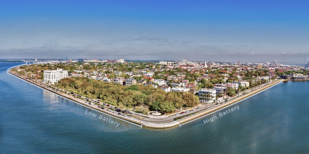
Charleston’s most famous waterfront is not a natural edge preserved under glass. It is a sequence of public works: early fortifications at White Point, a granite wall that made East Battery possible, a park built from filled land, a concrete Low Battery that created Murray Boulevard, and a modern restoration that raised and strengthened the wall for the next century of water.
Built in the Water
The short version is not that Charleston built a pretty promenade beside the water. The city repeatedly built into the water, filled behind the walls, repaired what storms broke, and then renamed the result as if it had been there all along.
That history matters because the Battery is both landmark and working edge. It has always been scenic, expensive, public, and vulnerable at the same time.
High and Low
Made land
Never finished
White Point
Early Charleston did not begin with a polished waterfront walk at the southern end of the peninsula. The first settlers favored higher and drier ground farther north, while the low ground around White Point remained exposed to tide, storm, and military concern.
The name itself came before the landmark. Sources describe early references to Oyster Point and White Point around the meeting of the Ashley and Cooper Rivers, where sand and bleached oyster shells marked the southern edge. The later Battery was not discovered there. It was built there.
White Point therefore belongs at the beginning of the story, but not as a postcard. It was a working edge: unstable land, strategic position, potential waterfront, and persistent problem. Charleston’s later genius was making the problem look scenic.

Oyster Point, White Point, then The Battery
Wood • Earth • Brick • Cannon
The first hard edge at White Point was practical and defensive. In the 1720s, waterfront owners were ordered to mark and secure their holdings with wooden pilings and ballast stones. By the 1730s and 1740s, Broughton’s Battery, earthen ramparts, and gun batteries turned the southern point into a fortified landscape.
Storms were already part of the design review process, though the minutes were wet. The hurricane of 1752 damaged much of the earlier work, leading to more substantial fortification under the engineer William De Brahm.
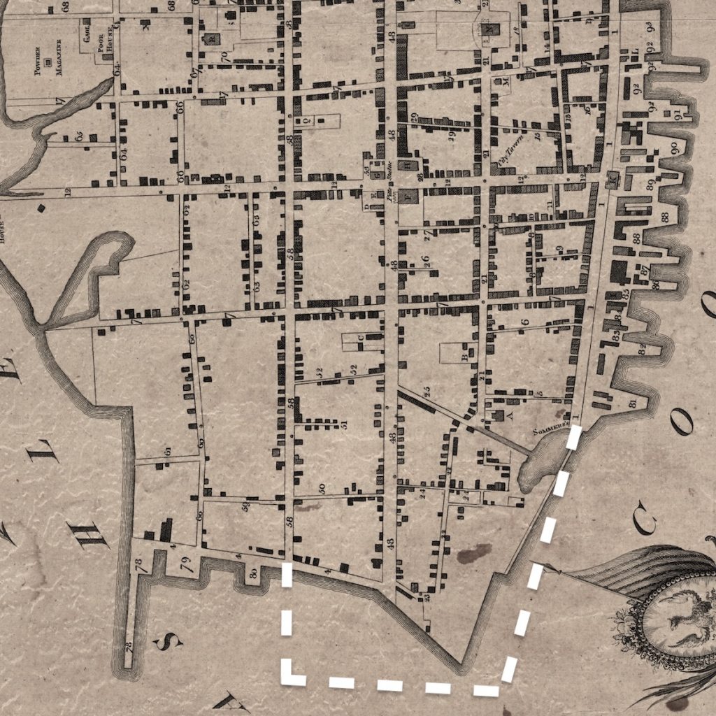
By the late 1760s, a brick and Bermuda-stone wall traced a long zig-zag around White Point. Behind it, workers dumped soil and effectively lifted the old beach into more stable ground. The purpose was not leisure. Charleston was manufacturing a defendable edge at the place where water, ships, and military anxiety met.
The early construction sequence
- Wood and ballast to stake and hold the edge.
- Earth ramparts to support military defenses.
- Brick and stone to protect the works from tide and storm.
- Fill to raise the land behind the wall.
The High Battery

After the Revolution, Charleston began dismantling the old fortifications and imagining a more civic waterfront. The city wanted to extend East Bay Street southward toward White Point, creating the road and promenade we now associate with East Battery.
The small inconvenience was that the proposed street lay in the Cooper River. Charleston’s plan was not to improve existing waterfront land. It was to make the land first and then act as if the result had been obvious all along.
Early attempts failed repeatedly. Palmetto-log “hog pens” filled with ballast stone were washed away. A brick wall followed and then failed as well. After storms ruined successive efforts in 1797, 1800, and 1804, the city finally adopted the more expensive answer: imported granite blocks. Construction resumed in 1808 and, after a decade of work, the seawall known as the High Battery was completed at the end of 1818.
The important distinction
White Point Garden

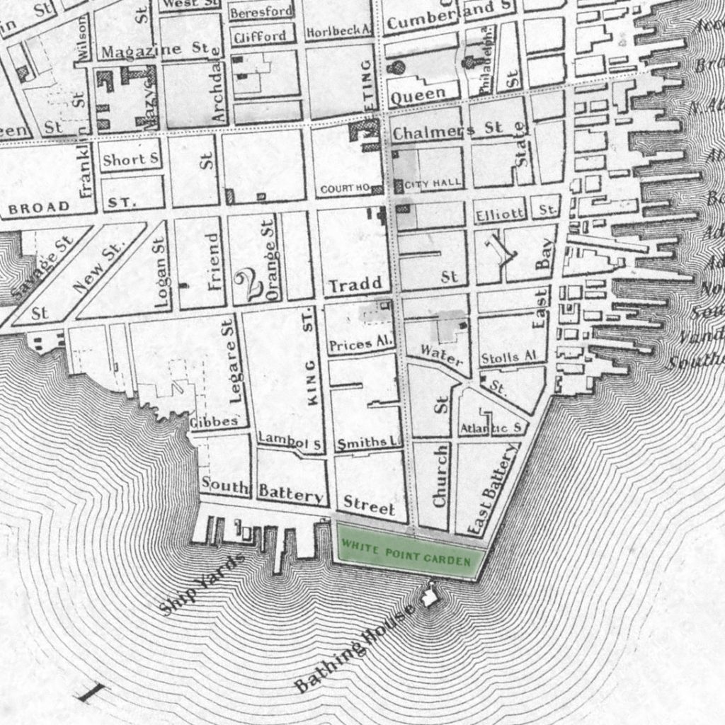
White Point Garden can feel like old open space that Charleston wisely left alone. That is too simple. The park opened to the public in the late 1830s on made land, then expanded westward in the 1840s and early 1850s as the city extended seawalls, filled behind them, planted the ground, and gradually shaped the public garden.
The result became Charleston’s first major public park, but the park never left history behind. During the Civil War, it again became a place for artillery. Today’s cannons, monuments, plaques, and statues are not decorative clutter so much as visible residue from the park’s recurring assignment: scenery with civic memory attached.
The 1854 hurricane damaged the Battery and White Point Garden and forced new repairs. City engineer Charles Parker recommended raising portions of the wall. That pattern — build, admire, storm, inspect, repair, raise — did not end in the nineteenth century. It is basically the Battery’s long-term maintenance plan, with better stationery.
Fits & Starts
The Low Battery and Murray Boulevard were not sudden twentieth-century ideas. Charleston had been thinking about a western waterfront improvement for decades before the work finally happened. The idea kept returning, usually just in time to meet a legal dispute, economic panic, war, or some other civic headwind wearing a better hat.
Extend White Point Garden
Ashley River Embankment
The boulevard revival
The Low Battery

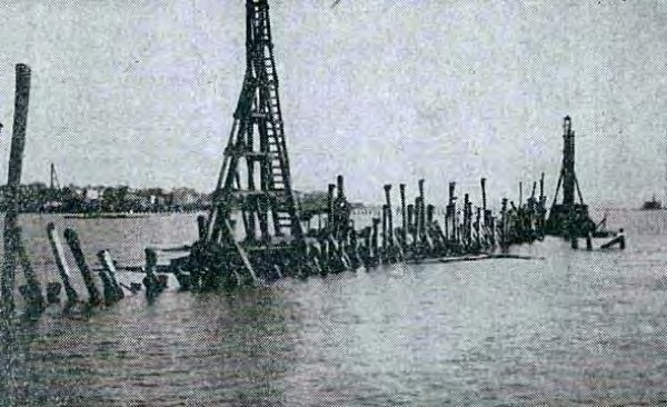
The long-delayed boulevard project finally broke ground in July 1909 under Mayor Robert Goodwyn Rhett. The first phase ran from King Street to the west end of Tradd Street and was completed in 1911 after more than two years of work. A new concrete wall was built into the Ashley River, and dredged material was pumped behind it to create new land.
That new land eventually became a residential waterfront along Murray Boulevard. The houses came after the infrastructure, not before it. The Low Battery was less a decorative wall than a landmaking machine with a view.
Andrew Buist Murray helped force the issue. In 1916, he pledged up to $40,000 to help pave the unnamed boulevard and connect it to East Battery. The final work, delayed by wartime material and labor shortages, connected the Low Battery to the older High Battery and pushed a roadway through the edge of White Point Garden.
The automobile won that argument, as it so often did in the twentieth century, though not without local opposition. Residents objected to sending cars through one of Charleston’s most beloved public landscapes. The cars arrived anyway. They have been circling the point ever since, very pleased with themselves.
Low Battery facts
- Groundbreaking
- July 1909
- First phase
- King Street to Tradd Street, completed 1911
- Connection to High Battery
- 1917–1922
- Named for
- Andrew Buist Murray
Stopping Short
Earlier plans for Murray Boulevard imagined a scenic western promenade continuing toward Spring Street and even Hampton Park. Andrew Murray’s later bequest was intended to support the next phase northward, but the Great Depression made the larger plan impractical.
Lockwood Drive would eventually follow part of the general western waterfront idea, but not as the grand scenic promenade the early boosters imagined.
What the larger plan imagined
- A western seawall beyond the Low Battery
- A scenic boulevard toward Spring Street
- A possible extension toward Hampton Park
- New public space and taxable land along the Ashley
Modernizing the Low Battery
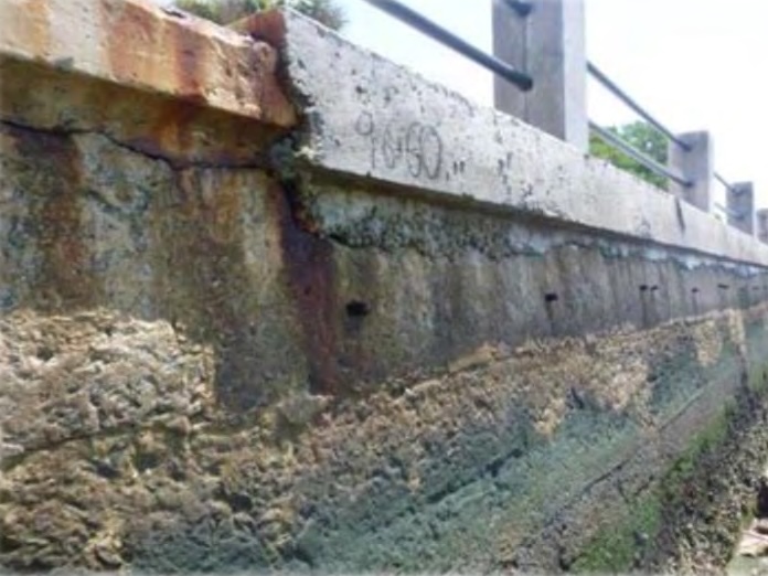
The twentieth-century Low Battery did its work for a long time, but it was never magic. The original concrete wall reflected the methods, compromises, and material limits of its era. By the early twenty-first century, the Low Battery had become both historic infrastructure and aging infrastructure, which is an expensive combination.
The City of Charleston completed the Low Battery Restoration Project in 2026, strengthening nearly 5,000 feet of waterfront, raising portions of the wall, improving the public promenade, and rebuilding drainage and utility systems for a wetter future.
The restoration did not make the Battery invulnerable. That would require a different genre, probably fantasy. It did raise and strengthen the public edge, improve access, and continue the same long pattern that began at White Point: Charleston making land, defending land, and repairing land.
The Battery endures as part fortification, part promenade, part park, part neighborhood edge, part storm defense, and part urban self-portrait – which is a lot of responsibility for a sidewalk with a view.
What changed in the recent restoration
- A stronger Low Battery wall and foundation
- Raised sections along Murray Boulevard
- Expanded stormwater capacity
- Tidal check valves and drainage improvements
- Improved crossings, sidewalks, parking, landscaping, and ADA access