
$929,000
5043 Spaniel Drive
Listed by Jeff Cook Real Estate LPT Realty


While the subject of walkability is a subjective, a few neighborhoods in and around Charleston stand out for their livable designs. They are not identical, and that is the point – some were built out before the motorized automobile came about, others designed deliberately as a response to them. Some offer daily-use walkability; others offer recreation, dining, beach access, or a compact town-center lifestyle.
Founded in the 1910s, Park Circle in North Charleston is one of the earliest planned communities in the U.S., designed with principles from the Garden City and City Beautiful movements. Today, it remains a vibrant, walkable neighborhood with a blend of historic charm and modern amenities.
At its center is the recently redeveloped Park Circle itself, which now features a community building, farmers market pavilion, and the world’s largest inclusive playground. The park also offers a disc golf course, playgrounds, and green spaces, serving as a focal point for recreation and gatherings.
The neighborhood encourages exploration with tree-lined streets and mixed-use spaces. East Montague Avenue and Spruill Avenue feature popular local spots like Holy City Brewery, Firefly Distillery, and the Shops at Mixson. These destinations contribute to a lively atmosphere that attracts both residents and visitors.
Recreational opportunities extend beyond the central park, with Quarterman Park’s duck pond, pocket parks, and the Danny Jones Recreational Center offering sports facilities and community programs. Sidewalks, bike lanes, and multi-use paths further promote walking and biking for both errands and leisure.
Park Circle works because the central park, older street pattern, and East Montague commercial corridor give walking a real destination structure.


The Old Village in Mount Pleasant is a historic, walkable neighborhood that blends coastal charm with modern conveniences. As one of the oldest communities in the Charleston area, it features a mix of 19th-century homes and newer residences, offering a picturesque setting defined by tree-lined streets, waterfront views, and easy access to local shops and restaurants.
At the heart of the neighborhood is Pitt Street, a popular corridor with small businesses, cafes, and the historic Pitt Street Pharmacy. Residents can enjoy waterfront parks like Alhambra Hall and stroll along the scenic Pitt Street Bridge, which offers panoramic views of Charleston Harbor and is a favorite spot for walking, fishing, and birdwatching.
The Old Village’s design promotes outdoor living, with several pocket parks, playgrounds, and nearby access to Shem Creek, where residents can enjoy kayaking, paddleboarding, or dining along the waterfront. Sidewalks and bike paths weave throughout the area, making it easy to explore the neighborhood or run errands without a car.
Old Village is one of the stronger examples of lifestyle walkability in Mount Pleasant, especially near Pitt Street, but the benefit is highly location-sensitive.


Downtown Summerville offers a blend of history, community, and modern convenience in a walkable, small-town setting. Known as the “Birthplace of Sweet Tea,” it features historic homes, brick-paved streets, and a vibrant local culture. The neighborhood’s layout encourages exploration, with shops, restaurants, and parks within easy walking distance.
Hutchinson Square, the centerpiece of the downtown area, serves as a gathering spot with green spaces, benches, and regular events like farmers markets and festivals. The square is surrounded by popular local destinations, including antique stores, boutiques, and dining options such as the family-owned Italian restaurant, The Icehouse, and the renowned Sweetwater One Twenty Three.
Parks and outdoor spaces are integrated throughout the area. Azalea Park, just a short walk from the main square, offers peaceful walking trails, gardens, and sculptures. Sidewalks and bike lanes connect the downtown area with nearby neighborhoods, making it easy for residents to complete errands or enjoy recreational activities without needing a car.
Downtown Summerville is walkable in the historic core; outside that core, the usual suburban pattern resumes its shift.


Carnes Crossroads is a master-planned community near Summerville that tries to solve a very suburban problem: how to build new neighborhoods that feel connected before everyone gives up and drives three blocks. Set between the towns of Summerville and Goose Creek, it combines traditional neighborhood design – integrating parks, trails, schools, healthcare, and most notably, neighborhood-scale commercial areas into a more intentional pattern than the usual subdivision-and-strip-center arrangement.
The community common areas are organized around connected streets, green spaces, and gathering places rather than just a clubhouse and pool. The Green Barn has served as one of the neighborhood’s recognizable civic anchors, while newer amenities such as The Lakehouse, Fresh Picks Café, the Wellness Center, sports courts, and resort-style pool areas add more daily-use destinations within the community itself. That does not make Carnes Crossroads a downtown, but it does give residents more reasons to move through the neighborhood on foot or by bike.
Outdoor space is one of the stronger pieces of the design. Parks, lakes, open lawns, trails, and community gathering areas are woven through the neighborhood, creating a more useful pedestrian network. The broader development also includes access to shops, restaurants, schools, and healthcare, which helps move it closer to practical walkability than many traditional suburban developments.
The tradeoffs are scale and, potentially, location. Carnes Crossroads is planned for walking, but it is still a large suburban community, and daily life will vary depending on where a specific home sits in relation to the commercial areas, schools, trails, and amenities. It is best understood as designed neighborhood walkability: most everything you need is within easy reach, though getting anywhere else may involve a freeway.
Carnes Crossroads is one of the better examples of new suburban walkability in the Summerville area – with trails, parks, amenities, and neighborhood destinations built into the plan. The usefulness depends heavily on the exact home location; this is connected suburban design, not historic downtown proximity.


The Avondale and Ashley Forest neighborhoods in West Ashley offer a lively, walkable lifestyle with a mix of historic charm and modern amenities. Known for their mid-century architecture and tree-lined streets, these communities attract residents with a variety of local businesses, green spaces, and a convenient location just minutes from Downtown Charleston.
At the heart of the area is the Avondale business district, a bustling corridor of restaurants, cafes, and boutiques. Popular spots include Triangle Char & Bar, Avondale Wine & Cheese, and the eclectic Mellow Mushroom. Street art and murals add to the district’s vibrant, creative atmosphere, making it a favorite destination for locals and visitors alike.
Outdoor spaces are easily accessible, with nearby Charles Towne Landing offering historical exhibits, walking trails, and wildlife encounters along the Ashley River. Residents can also enjoy the West Ashley Greenway, a multi-use path ideal for walking, running, or biking. Sidewalks, bike lanes, and pedestrian-friendly streets encourage car-free exploration throughout the area.
Avondale’s walkability is concentrated around the business district and nearby residential streets, with the West Ashley Greenway adding useful recreational and bike connectivity.


Daniel Island offers a walkable, master-planned community that combines coastal beauty with modern amenities. Located between the Cooper and Wando Rivers, this neighborhood features a mix of residential areas, parks, and commercial hubs, all connected by pedestrian-friendly streets and scenic trails.
The town center serves as the heart of the island, with shops, restaurants, and cafes that cater to both residents and visitors. Popular spots include The Kingstide, a waterfront seafood restaurant, and Blondies Bagels & Café. The Credit One Stadium, a premier venue for concerts and tennis tournaments, adds to the island’s lively atmosphere.
Daniel Island is known for its abundant outdoor spaces. Residents can enjoy miles of walking and biking trails that wind along rivers, marshes, and parks. Waterfront Park and Smythe Park, with its iconic lake and playground, are popular destinations for recreation and relaxation. Golf enthusiasts can also take advantage of the island’s two private courses, including the acclaimed Daniel Island Club.
Daniel Island has planned trails, parks, and a town center, but its scale means many residents still rely on a car for daily errands. It is designed walkability, not downtown-style proximity.


Folly Beach offers a walkable, relaxed lifestyle known for its eclectic vibe and stunning coastal scenery. Situated on a barrier island just south of Charleston, this vibrant community blends surf culture, local dining, and natural beauty, making it a favorite destination for residents and visitors alike.
Center Street serves as the heart of Folly Beach, featuring a variety of local restaurants, bars, and shops. Popular spots include Taco Boy, The Crab Shack, and Rita’s Seaside Grille. Live music venues and open-air cafes add to the area’s lively, beach-town atmosphere.
Outdoor activities abound, with easy access to the beach and Folly River. Surfing, paddleboarding, and fishing are favorite pastimes, and visitors can explore the iconic Folly Beach Pier or the scenic paths at Folly Beach County Park. Just a short bike ride away, the Lighthouse Inlet Heritage Preserve offers stunning views of the Morris Island Lighthouse and opportunities for birdwatching.
Sidewalks, bike lanes, and golf cart paths make it easy to explore the area without a car. Whether strolling along the beach, dining on Center Street, or enjoying water activities, Folly Beach offers a walkable, laid-back lifestyle that perfectly balances recreation and relaxation.
Folly is a walkable town for beach life, dining, and recreation. It is less complete as daily-needs walkability, and seasonal traffic can change the experience substantially.


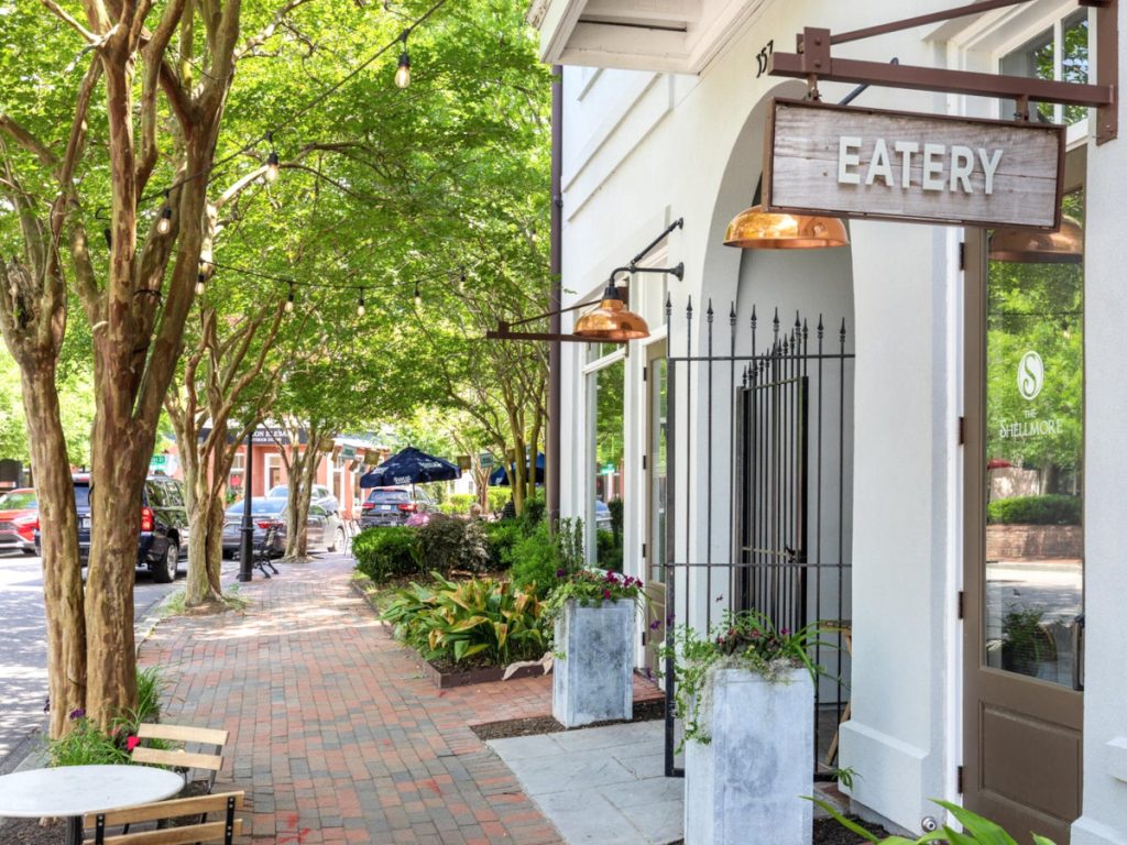
I’On in Mount Pleasant is a thoughtfully designed, walkable community that blends Southern charm with modern living. Inspired by traditional neighborhood design, I’On features elegant homes, tree-lined streets, and public squares, fostering a sense of community and ease of exploration on foot.
The heart of the neighborhood lies along Shelmore Boulevard and I’On Square, where cafes, restaurants, and boutiques create a lively, village-like atmosphere. Popular local spots include The Square Onion for gourmet sandwiches and O’Brion’s Pub for casual dining. Regular events, such as farmers markets and outdoor concerts, enhance the area’s vibrant social scene.
I’On offers a variety of green spaces, including the tranquil lakes of Eastlake and Westlake, where residents can enjoy kayaking or paddleboarding. The I’On Club provides recreational facilities, including tennis courts, pools, and fitness programs. Walking paths, nature trails, and pocket parks are seamlessly integrated throughout the neighborhood, promoting outdoor activity.
I’On is one of the area’s clearest examples of neighborhood design intentionally supporting walking, with a village center, public spaces, and connected streets, though its price points remain exclusive.


A genuinely walkable neighborhood makes ordinary trips practical on foot. Sidewalks help, but the larger system matters more: connected streets, short blocks, nearby destinations, safe crossings, shade, and buildings that make the street feel comfortable rather than leftover.
Urban planner Jeff Speck describes a successful walk as useful, safe, comfortable, and interesting. Charleston’s strongest examples tend to satisfy all four. A quarter-mile beneath mature trees, past porches and storefronts, is a very different proposition from a quarter-mile beside six lanes of traffic.
The Charleston Peninsula contains the region’s largest concentration of walkable neighborhoods, including South of Broad, Harleston Village, Ansonborough, and Cannonborough-Elliotborough. Older town centers and villages such as the Old Village, Park Circle, and parts of Avondale also pair connected streets with useful destinations.
Newer communities including I’On and portions of Daniel Island were designed to restore some of that traditional pattern. Even within these places, however, walkability can change from one block to the next. The useful question is not whether a community has sidewalks, but what you can safely and comfortably reach from a particular home.
Yes, but only in a limited part of the metro area. On much of the Peninsula, a resident may be able to reach work, restaurants, parks, and basic errands on foot or by bicycle. In a few other compact districts, living with one household car may be more realistic than living completely without one.
Across most of the region, major roads, bridges, dispersed shopping, and limited transit make regular access to a vehicle difficult to avoid. A home can feel pleasantly walkable on weekends while still requiring a car for groceries, school, medical appointments, or the daily commute.
Walk Score® is a useful starting point, but it should not be treated as the final word. It measures access to nearby destinations, yet it cannot fully judge whether the route is safe, shaded, direct, or remotely pleasant.
In suburban areas, a business may appear close on the map while sitting across a wide arterial road or behind several acres of parking. The score may also miss the practical effect of disconnected sidewalks, long blocks, poor drainage, and limited crossings. Use Walk Score® as a screening tool, then inspect the actual route on foot. The pavement generally offers a more candid review than the algorithm.
Walk the routes you would actually use – not merely the prettiest block near the listing. Check whether sidewalks continue, whether crossings feel safe, and whether groceries, parks, schools, restaurants, or transit are reachable without a major detour.
Pay attention to shade, drainage, lighting, bicycle conditions, and traffic speed. Charleston’s summer heat and humidity can make long walks or bike rides dangerous, particularly where there is little tree cover or no comfortable place to stop. A route that seems easy in March may become a different species by August.
I often encourage buyers to spend an hour walking a neighborhood before we focus on individual homes. It is one of the quickest ways to learn whether the place supports the daily life they actually want – and where a local comparison can save considerable guesswork.
Distance tells only part of the story. One neighborhood may have a connected grid, frequent intersections, mature trees, porches, and shops near the sidewalk. Another may rely on cul-de-sacs feeding into a collector road, forcing pedestrians to take a long route toward fast traffic before reaching anything useful.
Street connectivity, block length, building placement, crossings, tree canopy, and the mix of uses determine whether walking feels natural or like an improvised survival exercise. This is why two homes separated by half a mile can offer very different daily lives.
Walk the routes you would actually use – not merely the prettiest block near the listing. Check whether sidewalks continue, whether crossings feel safe, and whether groceries, parks, schools, restaurants, or transit are reachable without a major detour.
Pay attention to shade, drainage, lighting, bicycle conditions, and traffic speed. Charleston’s summer heat and humidity can make long walks or bike rides dangerous, particularly where there is little tree cover or no comfortable place to stop. A route that seems easy in March may become a different species by August.
I often encourage buyers to spend an hour walking a neighborhood before we focus on individual homes. It is one of the quickest ways to learn whether the place supports the daily life they actually want – and where a local comparison can save considerable guesswork.
As a Charleston native and systems‑oriented broker, I see homes as living systems, not just square footage. I’ll help you understand the daily rhythm, shade, breeze and tradeoffs that shape how a place actually lives. If you’re considering a move to the Lowcountry, let’s talk.