Charleston’s intentions for The Upper Peninsula Initiative are to direct population growth towards the city center in an effort to mitigate sprawl. Of the eight strategies implemented in the EcoDistricts framework, Urban Form & Pattern has the most apparent and enduring influence. The arrangement of building densities, their heights and architectural styles, as well as the natural environment and transportation infrastructures are all paramount in the planning for Charleston’s Upper Peninsula. This urban structure is fluid, changing over time in response to social, political, and economic interests, creating an evolving fabric that suits the needs of current and future growth.

At a public meeting on July 31, city planners laid out their research and outlined their initial recommendations. The area is dominated by industrial sites with unused parking lots and abandoned warehouses – as a prime target area for residential and commercial development, the city wants to have an active role in what that development will look like. “We didn’t come here tonight to say we’re going to build anything… we came here tonight because somebody else will build something,” Charleston planning director Tim Keane remarked during last Thursday’s public meeting. “The point of this is to work together and use this as a guide – we don’t want to react to development happening.”
Building for Density
Medium density buildings with active use ground floors on Broad Street
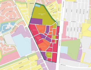
In planning for the physical configuration and arrangement of buildings in the Upper Peninsula, planners are using a strategy based on two key components. First, the district is delineated into primary thoroughfares (Meeting, Morrison, Brigade, Romney, Huger) and the secondary neighborhood streets that connect to them. Then, the heights and densities of buildings along those streets are planned to create an ideal alignment of form and function.

When speaking about building densities, we are accustomed to hearing restrictions on building heights in linear terms, such as 55 feet. However, this creates a couple of problems – some buildings require greater floor-to-floor heights for mechanical equipment, such as air handlers in commercial buildings, while others can get away with shorter heights, such as residential dwellings. Also, a linear height limit tends to create a ‘buzz-cut’ effect in which many buildings in an area are the exact same height. For these reasons, city planners are speaking in terms of stories.
Medium density buildings along primary streets would be limited to four stories, and require an active use on the ground floor. (What is an active use? An office, shop, or storefront – something that creates and supports liveliness along the street.) Higher density buildings up to 5 stories and “exceptional” buildings up to 8 stories are planned for the underutilized warehouse areas, specifically along the edge of the peninsula as well as on Huger Street – just look to East Central Lofts and a new hotel near the ramp of the Ravenel Bridge.

Getting Around
Transportation is key to any urban area, and we have a unique opportunity to create a broad transportation plan for the Upper Peninsula alongside growth patterns. For vehicles the recommendation is a collective parking strategy that is to be phased in as needed. Just like in the rest of the peninsula, there would be strategically located parking garages throughout the district so that every building would not require its own sprawling parking lot. Moreover, the city planners are incorporating a comprehensive bicycle strategy for the district.

As they considered the importance of bicycles to a healthy urban area, planners looked to the systematic approach employed by the city of London. They looked at the primary streets in the district, all of which currently have at least some bicycle traffic, and analyzed those streets by the amount of vehicular traffic and the average speeds of the vehicles. Using this data, a determination can be made of the type of bicycle facilities that would be most appropriate for each street:
- Shared use would continue to suit the lower volume internal streets
- Bicycle lanes on the higher volume streets – Meeting Street and Huger Street
- Protected bicycle lanes on high volume, high velocity streets – Morrison Drive and Meeting Street Extension – separated from vehicular traffic by a buffer of parallel parked cars, and perhaps landscaping or trees
- At high volume intersections, a priority traffic signal would allow safe crossing for pedestrians and cyclists

The City of Charleston and The Sustainability Institute continue to welcome ideas and feedback from the community during this planning process. The nature of the Upper Peninsula Initiative is one of collaborative effort, whose goal is for every Charlestonian to have a voice in what this next phase of our city will look and feel like.


